New NEXRAD Frequency Transmissions, Laser-Like Anomalies, Unprecedented Storm Path of Hurricane Milton Raise Questions (Video)
Hurricane Milton is taking a highly unusual west-to-east path across the Gulf, aiming for Florida's Gulf Coast—a rare trajectory for storms in this region.

In recent days, a powerful convergence of forces has caught the attention of residents and researchers alike: Hurricane Milton, a rapidly intensifying storm with an unusual west-to-east trajectory, is poised to bring catastrophic damage to Florida’s Gulf Coast, while peculiar NEXRAD radar transmissions raise questions about weather manipulation and storm guidance.
Follow Jon Fleetwood: Instagram @realjonfleetwood / Twitter @JonMFleetwood / Facebook @realjonfleetwood
NEXRAD Radar’s Potential Influence on Weather
The Next Generation Weather Radar, or NEXRAD, is a national network of Doppler radars managed by the National Weather Service.
These radars operate within the S-band frequency range of 2700 to 3000 MHz, with each radar pulse packing an astounding power of up to one Megawatt (1 million watts).
The energy from a single NEXRAD pulse equates to the power output of about 1,000 microwave ovens running at once.
Additionally, with its highly directional antenna, the NEXRAD system can concentrate these transmissions to an effective radiated power of 32 Gigawatts (32 billion watts).
Geoengineering researchers like Dane Wigington have pointed out that NEXRAD’s powerful pulses may influence weather patterns, especially when regions are infused with conductive nanoparticles.
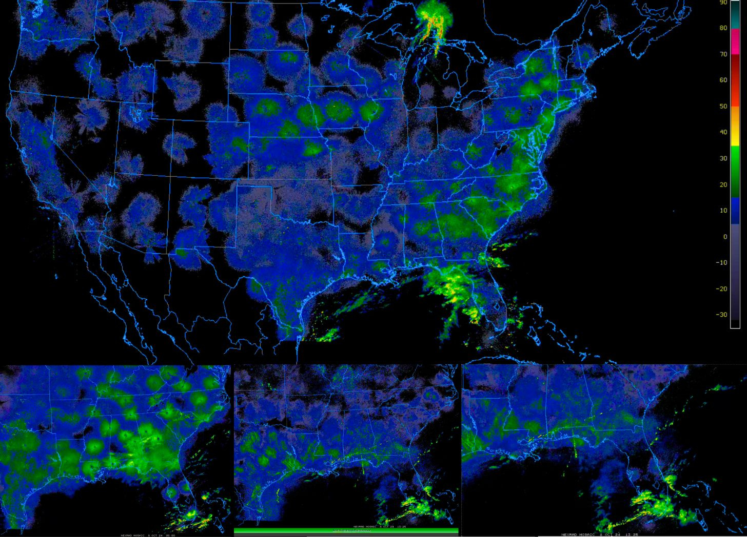
Theories suggest that NEXRAD transmissions, which manifest as bright flashes on radar, could repel or steer air masses, potentially influencing storm paths.
Observers report that these pulses appear as circular flashes on radar imagery, possibly indicating the guidance of Hurricane Milton toward a precise path over Florida’s Gulf Coast.
Unusual Characteristics of Hurricane Milton
Hurricane Milton has stunned meteorologists with its atypical behavior.
Most Gulf hurricanes form in the Caribbean and then move west before curving northward.
However, Milton’s path has defied convention, traveling from west to east as it barrels toward Florida.
Experts have noted that such a trajectory is exceedingly rare and raises questions about the storm’s unique development and intensification patterns.
According to a Reuters report, Milton’s rapid intensification, from a tropical storm to a Category 5 hurricane in less than 24 hours, ranks it among the fastest intensifying storms in Atlantic history.
Now downgraded slightly to a Category 4, Milton still packs maximum sustained winds of 155 mph.
Despite the downgrade, the National Hurricane Center warns of catastrophic damage along the coast, particularly around Tampa Bay, where the storm is expected to make landfall.
Atmospheric scientist Jonathan Lin from Cornell University emphasized the peculiarity of Milton’s path: “It is exceedingly rare for a hurricane to form in the western Gulf, track eastward, and make landfall on the western coast of Florida. This has big implications since the track of the storm plays a role in determining where the storm surge will be the largest.”
This deviation from typical Gulf storm behavior is prompting questions about whether natural forces alone are guiding Milton or if other factors might be at play.
Follow Jon Fleetwood: Instagram @realjonfleetwood / Twitter @JonMFleetwood / Facebook @realjonfleetwood
The Role of Frequency Pulses and Laser-Like Anomalies
Video of radar from the College of DuPage (COD) website shows strange blue flashes in radar imagery, which align with NEXRAD transmission pulses.
These blue flashes often form circular patterns around radar sites and are suspected to push air masses, clearing the way for storms like Milton to pass through.
You can also see laser-like anomalies over various areas, sparking concerns about more atmospheric manipulation.
Preparing for Landfall and Future Questions
As Milton inches closer to Florida, over a million people have been ordered to evacuate low-lying coastal areas.
Florida’s Gulf Coast, already reeling from Hurricane Helene just two weeks ago, is now on high alert, with officials urging residents to seek higher ground and follow evacuation orders.
Despite efforts to protect human life, the true nature of the NEXRAD transmissions and the implications of Milton’s unusual path remain uncertain.
Are NEXRAD transmissions simply collecting data, or could they also be influencing the weather systems they monitor?
What factors are behind Hurricane Milton’s unusual west-to-east path, and why are there reports of strange atmospheric pulses and laser anomalies?
As residents prepare for the storm, these questions linger, urging further investigation into the unseen forces that may shape our weather.
A Call for Transparency and Understanding
The connection between high-energy radar transmissions and unprecedented weather events like Hurricane Milton raises pressing questions that warrant thorough investigation.
Understanding the full impact of technology on weather patterns is essential for both public safety and scientific integrity.
For now, though, as Milton barrels toward Florida’s Gulf Coast, the focus remains on evacuation and preparation, even as questions continue to swirl about the unseen forces at play in our skies.
Follow Jon Fleetwood: Instagram @realjonfleetwood / Twitter @JonMFleetwood / Facebook @realjonfleetwood
Will NEXRAD Frequency Pulses Keep Hurricane Milton Localized to Florida? (Watch Video)
With Hurricane Milton now at a catastrophic Category 5, many are questioning if its trajectory is entirely natural—or if it’s being influenced by external factors.
Ex-U.S. Air Force Officer Exposes Government's Weather Modification and Chemtrail Activities (Video)
Kristen Meghan, a former U.S. Air Force officer who specialized in bioenvironmental engineering, has come forward with allegations that the U.S. government is involved in weather modification through the use of hazardous chemicals, a practice often referred to as “chemtrails.”
$2.5 Billion for Lithium: Pentagon, Department of Energy Funnel Billions Into U.S. Projects Before Hurricane Helene Flood Disaster, Fueling Online Speculation
The U.S. Department of Energy and the Pentagon have spent over $2.5 billion on lithium mining and battery projects in the lead-up to the catastrophic flooding caused by Hurricane Helene.
RFK Jr. Vows to End Chemtrails: 'We Are Going to Stop This Crime'
Robert F. Kennedy Jr. (RFK Jr.) on Monday vowed to stop airplanes from carrying out the “crime” of spraying chemicals, often referred to as “chemtrails,” into the sky behind them as they fly for geoengineering purposes.
Tennessee Says It Can't Enforce 'Chemtrail' Ban Because Federal 'Clean Air Act' Enforced by FAA Won't Let Them
Tennessee authorities are claiming they can’t enforce recently passed legislation in their state that prohibits geoengineering practices involving the release of chemicals into the sky, what some call “chemtrails,” because the state doesn’t have jurisdiction.


